The Circuit is Greater Philadelphia’s Regional Trail network. When complete, a 750 mile web of multi-use trails will put half of the metro area’s 5 million residents within one mile of a trail. Since 2008, nearly $50 million has been invested to design and build a regional trail network. Additionally for the first time, the regional trail network was included in the Delaware Valley Regional Planning Commission’s Long Range Plan. Since the formation of the Circuit Coalition in 2011, 25 miles of new trails have been opened bringing the grand total of completed Circuit miles to 275.
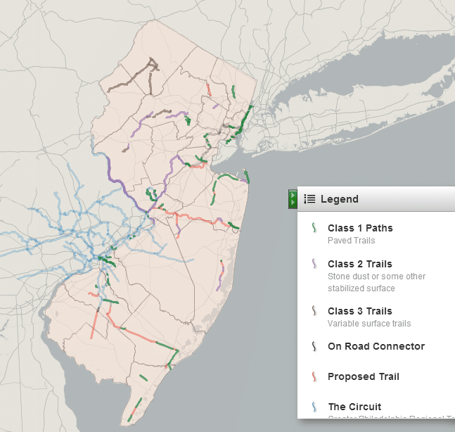
In New Jersey, four counties – Mercer, Burlington, Camden and Gloucester – are included in the Circuit and all have made progress on trail development (although their level of investment is dwarfed by the advanced planning efforts in Montgomery, Philadelphia and Chester Counties in PA). But the good news for the rest of New Jersey is that there is a great potential to connect the Circuit with the rest of the state is as shown in the map below.
View the interactive map on Geocommons
The Circuit, faintly outlined in light blue, connects to several planned and existing corridors in Central and Southern New Jersey. The East Coast Greenway will serve as the spine to link the Circuit to all of the northern counties.
To date, trails and paths in the state have not been planned in the context of connecting them together into a statewide system. The recommendations below are drawn from the NJ State Trails Plan (pdf) and lessons learned from developing The Circuit. Chapter 5 of the plan recognizes the vision of a statewide network “New Jersey’s cities and towns are also connected through an extensive intercommunity network of trails, including both on-road bicycle facilities and off-road walking and biking trails. Many connecting trails have been established within linear greenways that link parks and natural areas throughout the state.”
Recommendations:
Map and Classify the Trails – The definition of a trail is often in the eye of the beholder. The Highlands Trail, Patriots Path and the Henry Hudson Trail are three very distinctive types of trails. The Patriots Path is in fact quite problematic. It is actually a connected network of different trails with numerous spurs branching from the core alignment. Trail segments vary from paved trails to hike only singletrack. Yet unlike roads, there is no functional classification system and thus no way to provide clear guidance to trail users, builders and managers.
Where feasible, the statewide network trails should be built to shared use path standards. If paved shared use paths are not feasible or appropriate, then these trails should be designed as 10’+ wide crushed stone paths (<3/8″ aggregate) that are ADA accessible.
An interactive map that is ground-truthed to existing conditions can raise awareness for the trails, link users with the most convenient and appropriate trails and help define the needs to build out the network.
Bring in multiple partners – The statewide planning of trails is tasked to the Trails Council established by the plan. The seats of the council are mainly appointed to advocacy groups and state officials. Expanding that body in some capacity to include more stakeholders such as healthcare organizations, developers, foundations and engineering firms could help leverage trail building resources. Holding an annual trails conference could broaden the awareness of the Trails Council work.
Designate the trails that will make up the statewide network and identify the gaps. Think of the statewide trail network as the interstate system that will connect to many side trails. Identifying which trails are designated as part of the state network will help when it comes to prioritizing projects and estimating costs to build it out.
Brand the Statewide Network – The Circuit was coined by a naming contest mainly because the Philly Metro Area lacks a catchy regional moniker. (The Delaware Valley region isn’t in Delaware, nor is it a valley.) The “Garden State” at least provides a starting point for branding the statewide trail network.
Include the Trail Network In Long Range Transportation Plans – New Jersey’s 3 Metropolitan Planning Organizations are required to develop long range transportation plans that look 25 years into the future. Bicycling and walking are recognized as legitimate forms of transportation and therefore trails should have access to all the resources available to the rest of transportation infrastructure network.
Provide Technical Assistance to Project Sponsors – Awarding federal Transportation Enhancements money to local municipalities and counties has been very difficult in New Jersey due to to the rigorous requirements attached to the federal money. As a result, the State has more than $40 million leftover that is unobligated (i.e. available). If this money is not awarded to qualified projects in the next few years, it will likely be rescinded and sent back to Washington. Project managers need the resources and the technical support to shepherd these projects through the federal process.
Provide the resources to bring existing trails and paths up to modern standards – Nothing dampens enthusiasm for new trails and paths than watching older nearby facilities slowly decay. Insufficient maintenance in New Jersey has taken its toll. Older trails are often unmarked at road crossings and even at trailheads.
An online trail maintenance reporting system should also be put in place. Users should be able to pinpoint locations to problem areas which can often help trail managers resolves trail issues more efficiently. This can also establish a baseline to budget for maintenance.
John Boyle is Research Director for the Bicycle Coalition of Greater Philadelphia.


